Walk Summary
Walk Description
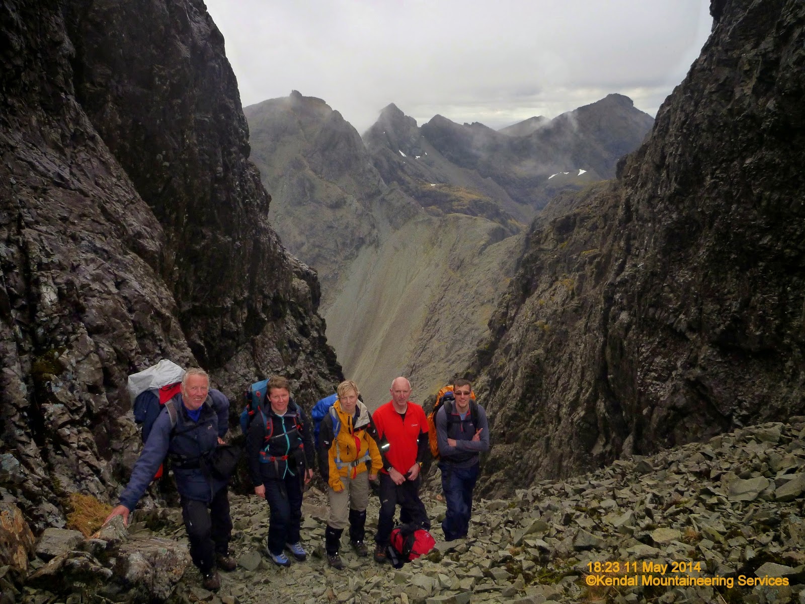
Setting
Kendal Mountaineering Services blog page
If like me you are just the average hill walker with no climbing expertise and limited scrambling experience, but have set yourself the target to climb all the Munros. Have you thought about how you will reach the 11 Munros on the Cuillin Ridge, Isle of Skye. From what I have read and now seen you will have no chance unless you know an experienced climber with knowledge of the Cuillins. Iain Gallagher of Kendal Mountaineering Services is just such a man. He has a lifetime of mountaineering experience along with a detailed knowledge of the Cuillins including safe scrambling routes along with entry and exit routes to take the safest option whatever the conditions might be or indeed change whilst out on the hill.
I found his services on line and paid the £425 for one weeks accommodation and 4 days guided walking (scrambling and climbing) in the Cuillins. Excellent value. 4 days guided walking alone could cost you that much. This price really includes food as well, because each member of the group, including Iain, supply a home cooked meal each day, creating a brilliant atmosphere and get together at the end of the day with everyone else in the team.
Team is just what you are part of, supporting each other throughout the day ensuring each and every one of us reaches our own goals as well as at times extend outside your own comfort zone and edge of achievable limits.
A brilliant experience. No kickbacks or commissions, but I cannot recommend this trip highly enough and thank Iain most sincerely for enabling me to extend myself beyond limits I never thought possible. As I have read somewhere "you do not know your limits or what you are capable of achieving until you start to venture beyond your limits."
Iain provided the opportunity and maintained the safe environment to do just that.
As well as taking copious amounts of photographs he also records the days events on his own blog to provide lasting memories of a trip of a lifetime. Here is his account of Day04 activities on the Cuillin Ridge - Sgurr Nan Gillean to Bruach Na Frithe
Walk Statistics
Walk Date - 15 May 2014
Walkers - Iain Gallagher (ML Kendal Mountaineering Services), Steve Smith, Al Simpson, Helen McD, Don, Alison L
Accommodation - Carbost, Isle of Skye
Start Point - Layby on A863 near Sligaachan Hotel (NG 48380 29754)
Start Time - 09:02
Finish Point - Layby on A863 near Sligaachan Hotel (NG 48380 29754)
Finish Time - 18:32
Duration - 9hrs 30mins
Average pace - 0.87mph
Distance Walked - 8.25miles
Height Ascended - 1251.32metres
Other walks on this trip
2014
May
08th The Tyndrum Handful
11th Cuillin Ridge Day01 - Sgùrr nan Eag, Sgùrr Dubh Mòr & Sgùrr Alasdair
12th Cuillin Ridge Day02 - Sgùrr Mhic Choinnic
13th Cuillin Ridge Day03 - Sgùrr a'Mhadaidh
15th Cuillin Ridge Day04 - Sgùrr nan Gillean & Bruach na Frithe
Peaks visited
Munro (282)
Sgùrr nan Gillean (18)
Bruach na Frithe (19)
Murdo (443)
Sgùrr nan Gillean (26)
Bruach na Frithe (27)
Corbett (221)
NONE
Graham (224)
NONE
Marilyn (1218S - 1552E,W&S))
Sgùrr nan Gillean (19S - 90E,W&S)
Hump (2168S - 2976E,W&S)
Sgùrr nan Gillean (23S - 144E,W&S)
Big day for me today as had to get back on the hill after coming off early
two days earlier on Sgùrr a'Mhadaidh. With a rest day yesterday, extra support
from the ML and rest of group I was fine and manged a roped descent down a
shoulder of volcanic rock and an abseil down Tooth Chimney. Not only that it
was pouring with rain and strong south westerly winds. Not to mention
improvised winter skills over snow banks which have usually long gone by May in
previous years. Because of the wet and wind we had to abandon plans to ascend
Am Bastier as the ascent is not only exposed but like soap on the Basalt dikes.
A fantastic day and proof I was back on the hill but with the loss of Am
Bastier, InPin as well as the two peaks from Day 03 meant I only managed 7 of
the 11 peaks. The rest of the group managed 9 though which considering the
conditions for the week was a good haul and remarkable achievement for the ML
to get us over that many.
A fantastic week.
Walk Description
Setting
Kendal Mountaineering Services blog page
If like me you are just the average hill walker with no climbing expertise and limited scrambling experience, but have set yourself the target to climb all the Munros. Have you thought about how you will reach the 11 Munros on the Cuillin Ridge, Isle of Skye. From what I have read and now seen you will have no chance unless you know an experienced climber with knowledge of the Cuillins. Iain Gallagher of Kendal Mountaineering Services is just such a man. He has a lifetime of mountaineering experience along with a detailed knowledge of the Cuillins including safe scrambling routes along with entry and exit routes to take the safest option whatever the conditions might be or indeed change whilst out on the hill.
I found his services on line and paid the £425 for one weeks accommodation and 4 days guided walking (scrambling and climbing) in the Cuillins. Excellent value. 4 days guided walking alone could cost you that much. This price really includes food as well, because each member of the group, including Iain, supply a home cooked meal each day, creating a brilliant atmosphere and get together at the end of the day with everyone else in the team.
Team is just what you are part of, supporting each other throughout the day ensuring each and every one of us reaches our own goals as well as at times extend outside your own comfort zone and edge of achievable limits.
A brilliant experience. No kickbacks or commissions, but I cannot recommend this trip highly enough and thank Iain most sincerely for enabling me to extend myself beyond limits I never thought possible. As I have read somewhere "you do not know your limits or what you are capable of achieving until you start to venture beyond your limits."
Iain provided the opportunity and maintained the safe environment to do just that.
As well as taking copious amounts of photographs he also records the days events on his own blog to provide lasting memories of a trip of a lifetime. Here is his account of Day04 activities on the Cuillin Ridge - Sgurr Nan Gillean to Bruach Na Frithe
Walk Statistics
Walk Date - 15 May 2014
Walkers - Iain Gallagher (ML Kendal Mountaineering Services), Steve Smith, Al Simpson, Helen McD, Don, Alison L
Accommodation - Carbost, Isle of Skye
Start Point - Layby on A863 near Sligaachan Hotel (NG 48380 29754)
Start Time - 09:02
Finish Point - Layby on A863 near Sligaachan Hotel (NG 48380 29754)
Finish Time - 18:32
Duration - 9hrs 30mins
Average pace - 0.87mph
Distance Walked - 8.25miles
Height Ascended - 1251.32metres
Other walks on this trip
2014
May
08th The Tyndrum Handful
11th Cuillin Ridge Day01 - Sgùrr nan Eag, Sgùrr Dubh Mòr & Sgùrr Alasdair
12th Cuillin Ridge Day02 - Sgùrr Mhic Choinnic
13th Cuillin Ridge Day03 - Sgùrr a'Mhadaidh
15th Cuillin Ridge Day04 - Sgùrr nan Gillean & Bruach na Frithe
18th Comb Moss
Peaks visited
Munro (282)
Sgùrr nan Gillean (18)
Bruach na Frithe (19)
Murdo (443)
Sgùrr nan Gillean (26)
Bruach na Frithe (27)
Corbett (221)
NONE
Graham (224)
NONE
Marilyn (1218S - 1552E,W&S))
Sgùrr nan Gillean (19S - 90E,W&S)
Hump (2168S - 2976E,W&S)
Sgùrr nan Gillean (23S - 144E,W&S)
Bruach na Frithe (24S - 145E,W&S)
Route
Our days route as plotted on my GPS tracklog.
Please do not think without the necessary experience or knowledge of The Cuillins this is the basis of a route you can tackle alone or even part of a determined group. The contours are simply too close together along with scree, outcrop, boulder and loose rock symbols so arbitrary, that plotting a route from your armchair or even on the ground are just too complex.

More Photographs
Our days route as plotted on my GPS tracklog.
Please do not think without the necessary experience or knowledge of The Cuillins this is the basis of a route you can tackle alone or even part of a determined group. The contours are simply too close together along with scree, outcrop, boulder and loose rock symbols so arbitrary, that plotting a route from your armchair or even on the ground are just too complex.
More Photographs
Not having a lot of luck with my camera on this trip. Turned on camera to take photos of setting off at start of walk and battery was flat.
Once again I am without my own camera so only photos taken by me are on my smartphone.
Remaining photos taken by other members of group and in particular Iain Gallagher of Kendal Mountaineering Services .
Once again I am without my own camera so only photos taken by me are on my smartphone.
Remaining photos taken by other members of group and in particular Iain Gallagher of Kendal Mountaineering Services .
 |
Heading towards Sgùrr Dearg - The Inaccessible Pinnacle shrouded in cloud and probably rain
Click on photograph to view slide-show
|