Walk Date - 07 September 2013
Walkers - Steve Smith, John Parkin
Accommodation - West Lodge Caravan Park, Comrie
Start Point - Coishavachan car park (GR NN 74301 27278)
Start Time - 10:49
Finish Point - Coishavachan car park (GR NN 74301 27278)
Finish Time - 15:12
Duration - 4hrs 23mins
Average pace - 1.90mph
Distance Walked - 8.34miles
Height Ascended - 760.28metres
Other walks on this trip
2013
September
14th The Glen Lyon Horseshoe
13th Tarmachen Ridge
12th Meall Ghaordaidh
9th Beinn Chabhair
7th Ben Chonzie
6th Ben Vorlich & Stuc a' Chroin
Peaks visited
Munro (282)
Ben Chonzie (3)
Murdo (443)
Ben Chonzie (3)
Corbett (221)
NONE
Graham (224)
NONE
Marilyn (1216)
Ben Chonzie (6)
Hump (2168)
Ben Chonzie (6)
Route
 |
| GPS tracklog of actual walk |
Ben Chonzie was originally planned by John P. as the first peak of the trip and therefore my very first Munro. However when I started reading that it was a boring hill and comments that it would put me off hill walking for life I did start (for about 1 nano-second) to have mixed feelings about it being the first. Quite frankly I can not imagine any hill, let alone a Munro, could put me off hill walking, unless of course a John Lewis or Debenhams had opened near the trig point.
Anyway when the forecast for Saturday was rain John decided to do Ben Vorlich & Stuc a' Chroin yesterday on the basis we would still be able to do Ben Chonzie if visibility was poor.
As forecast it was raining when we left the campsite, driving through rain along Glen Lednock. But by the time we had arrived at the start point and kitted up, we set off in bright warm sunshine from the car park towards Coishavachan Farm. All I could think about was the lush green fields, white sheep and the contrasting grays and browns towards the high fells - how is this boring.
Yes the navigation following the track for the next 1¾ hours and 3 miles is straight forward, but the relentless ascent provides an aerobic work out second to none, not to mention the fresh air, wildlife and spectacular views.
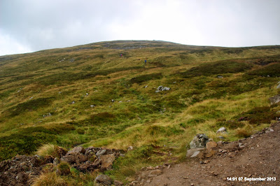
For me there was also a twist. The big lump we had walked towards and round was not Ben Chonzie. The summit was about 400m to the NW. Clearly if I had studied the map before setting off this would not have been a surprise, but for once I was just happy to follow John and let him worry about the navigation.
Verdict - Ben Chonzie is not a boring Munro at all. I do not believe there is such an animal. What has occurred to me though is that it is an excellent candidate for a last Munro. Whilst not taking any walk for granted (even on this walk the wind was cold and strong enough on the summit to not hang around and to don hat and gloves) the straight forward navigation and close proximity to a suitable start point makes it ideal as a last top to be joined by friends not quite so keen to disappear in to the Scottish Highlands for the whole day or even longer.
But for me that is a question I will not have to consider for about 280 summits and several years.
Walk Description
 |
| Coishavachan from walk start point |
 |
| Last look at van and walk start point from Coishavachan. |
 |
| First Invergeldie Burn crossing. Follow road through gate and round to the right |
 |
| The days only summit - Ben Chonzie after first crossing Invergeldie Burn |
 |
| Ford over Invegeldie Burn near small dam |
 |
| Small cairn marks top of track from where you drift left along path to Ben Chonzie summit |
 |
| Keep to top of rocks then follow fence at the top |
 |
| Follow fence to the west for the easier ground and as a navigation aid, |
 |
| Follow fence to the right at 910m contour Ben Chonzie summit will be straight ahead to the north |
 |
| A big black cloud has appeared on our way down |
 |
| Starting to rain as we rejoin track we followed on ascent. |
 |
| After an hours walk through heavy rain nearly back at Coishavachan |
 |
| Invergeldie Burn crossing in middle of picture. Coishavachan and walks end is behind trees right of bridge |
 |
| Windy & Cold on Ben Chonzie summit |

No comments:
Post a Comment